An Introduction To Mandurah
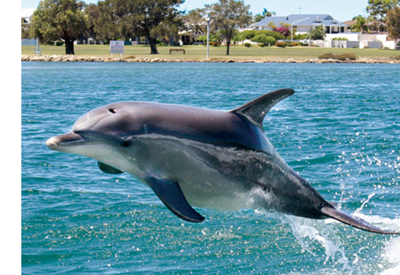
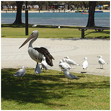
Mandurah is the second-largest city in W.A, located approximately 72 kilometres south of Perth. The city attracts a large number of tourists, including many international visitors. The city centre foreshore is home to a variety of wildlife including dolphins, pelicans, shags, and an abundance of marine life including the blue manna crab which has become synonymous with the area. The city is also known for its protected waterways, beaches and boating and fishing activities.
Geography
Mandurah has grown from isolated holiday communities along the shores of the Peel-Harvey Estuary to a major regional city in just over a decade, in a similar vein to the Gold Coast in Eastern Australia. In recent times, it has formed a conurbation with Perth along the coast; it is only 18 km south of Rockingham, a southern suburb of Perth. Mandurah has also become a popular lifestyle alternative for Perth retirees and its connection with the Perth CBD has been strengthened with the opening of the Perth-Mandurah railway line in December 2007 and a direct road connection to the Kwinana Freeway built by late 2010. A housing affordability survey of 227 cities in 2008 ranked it the least affordable city in Australia.
We live in such a beautiful part of W.A. that is rapidly growing and changing, it really is the best of both worlds… you’ll sure love it here!
There are a wide range of house styles and prices to ensure you will find a home that’s perfect for you. If your thinking about buying here, do some research and find out more about our area.
Geology
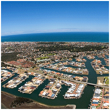
The waters of the Peel Inlet and Harvey Estuary (one of Australia’s larger inlet systems) form the centre of Mandurah. The estuary is approximately twice the size of Sydney Harbour. The city lies in and around this freshwater system which in turn feeds into the Indian Ocean. The city and its suburbs have many kilometres of ocean coastline most of which is sandy beaches. Mandurah also has a number of suburbs built around artificially created canal systems that extend from the Peel Inlet, such as Halls Head, Dudley Park and Wannanup. In terms of geology, much of Mandurah lies on the dune systems which dominate South Western WA’s coastline, progressively grading towards the Swan Coastal Plain as one travels inland. The area has infertile soils due to the dunes being rather sandy, having poor water retention qualities. Limestone outcrops are found to the north of the city especially along the Mandurah Line. Mandurah is the closest city to Yalgorup National Park which is home to modern thrombolites as well as an array of flora and fauna.
Mandurah is located in the Swan Coastal Plain ecoregion. The ecoregion contains an array of vegetation, from coastal dune and sandplains to banksia and eucalypt woodlands. Mandurah is covered by shoreline and dune deposits from the Pleistocene and Holocene that overlie Paleozoic and Neogene deposits of the Perth Basin. Coastal dunes feature scrub-heath communities, though banksia low woodlands occur on the soils of coastal dunes. Progressing inland give way to eucalypt woodlands. Seasonal wetlands (dry in the summer and wet in winter) are the most diverse habitat in the Swan Coastal Plain, which Mandurah has several wetland regions around the Peel Inlet. The wetlands feature several osprey nests, spoonbill and darters. Other fauna includes galah, short-billed black cockatoo, long-billed black cockatoo, and Australian ringneck among others. Australian ringnecks face competition for nesting space from rainbow lorikeet, an introduced species in Western Australia, that has now spread to Mandurah. Despite attempts to eradicate rainbow lorikeets, the population has grown to the point that they can no longer be eradicated.
Political
Mandurah is typically considered a marginal area for both major parties at both state and federal politics. Northern Mandurah lies in the safe Labor seat of Brand, held by Gary Gray, while southern and central Mandurah lies in the more marginal Canning, held by the Liberal Party’s Andrew Hastie. State politics also highlight a significant divide, with northern and central Mandurah located in the safe Labor seat of Mandurah held by David Templeman, while southern Mandurah located in the safe Liberal seat of Dawesville, held by Deputy Premier Kim Hames.
Climate
Sharing a similar climate to Perth, Mandurah has a typical Mediterranean climate (Köppen classification Csa) with hot dry summers and mild wet winters. During summer (December to February), the average maximum temperature is 27 °C with an average minimum temperature of 19 °C. At its extreme it can get very hot, often having a couple of days exceed 40 °C in the latter half of summer. In winter (June to August), the average maximum temperature is 18 °C with an average minimum temperature of 9 °C. Mandurah’s proximity to the ocean moderates diurnal temperatures somewhat, with temperatures a few kilometres inland often 4 or 5 degrees warmer during summer days (or cooler during winter nights). Frosts are very rare as a result, but do occur annually around suburbs such as Greenfields. The current weather station opened in 2001 and is situated right on the coastline, causing data recorded to appear warmer during winter nights and cooler in summer days compared to surrounding areas.
Mandurah also receives a moderate though highly seasonal rainfall of about 850 mm a year, however recent trends have seen this once reliable rainfall drop significantly. In addition, most of the winter rains are usually accompanied by severe winds and storms capable of causing widespread damage, making Mandurah one of the windiest cities in Australia. These conditions are perfect for tornado formation, which Mandurah’s climate is remarkable for producing one of the highest densities of tornadoes in the world.
Summer storms are rare due to the Mediterranean climate in the city, but not unheard of. Mandurah was affected to a lesser degree than Perth in the 2010 Western Australian storms, but the 2011-12 summer was notable for Mandurah bearing the brunt of three severe thunderstorms. One such storm on 12 December 2011 gave Mandurah almost seven times its monthly average (69.4 mm compared to an average of 15.5 mm), which was eclipsed exactly one year later on 12 December 2012 (74.2 mm). Another storm on 20 January 2012 dumped 57 mm on the city causing power outages and flash flooding. One man and numerous buildings in the city were struck by lightning during the storm, which produced 2,300 strikes within 30 kilometres of the city, which was more than what neighbouring Perth receives in an entire year and comparable to the most severe electrical storms for which places in the tropics like Darwin are known.